


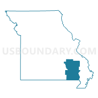
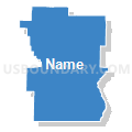
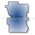
Butler, Ripley, Wayne, Madison, Iron, Reynolds & Carter Counties PUMA, Missouri
About
Outline

Summary
| Unique Area Identifier | 193293 |
| Name | Butler, Ripley, Wayne, Madison, Iron, Reynolds & Carter Counties PUMA |
| State | Missouri |
| Area (square miles) | 4,477.79 |
| Land Area (square miles) | 4,443.87 |
| Water Area (square miles) | 33.92 |
| % of Land Area | 99.24 |
| % of Water Area | 0.76 |
| Latitude of the Internal Point | 37.11111710 |
| Longtitude of the Internal Point | -90.68638940 |
Maps

Graphs
Select a template below for downloading or customizing gragh for Butler, Ripley, Wayne, Madison, Iron, Reynolds & Carter Counties PUMA, Missouri


Neighbors
Neighoring Public Use Microdata Area (by Name) Neighboring Public Use Microdata Area on the Map
- Cape Girardeau, Scott & Bollinger Counties PUMA, MO
- Craighead (West), Greene, Randolph, Lawrence & Clay Counties PUMA, AR
- Dunklin, Stoddard, New Madrid, Pemiscot & Mississippi Counties PUMA, MO
- Howell, Texas, Wright, Douglas, Oregon, Ozark & Shannon Counties PUMA, MO
- Phelps, Crawford, Dent, Gasconade & Maries Counties PUMA, MO
- St. Francois, Washington, Perry & Ste. Genevieve Counties PUMA, MO
Top 10 Neighboring County (by Population) Neighboring County on the Map
- St. Francois County, MO (65,359)
- Butler County, MO (42,794)
- Dunklin County, MO (31,953)
- Stoddard County, MO (29,968)
- Washington County, MO (25,195)
- Crawford County, MO (24,696)
- Perry County, MO (18,971)
- Randolph County, AR (17,969)
- Clay County, AR (16,083)
- Dent County, MO (15,657)
Top 10 Neighboring County Subdivision (by Population) Neighboring County Subdivision on the Map
- Poplar Bluff township, Butler County, MO (25,878)
- Liberty township, Stoddard County, MO (14,738)
- St. Michael township, Madison County, MO (7,056)
- Doniphan township, Ripley County, MO (5,656)
- Arcadia township, Iron County, MO (5,576)
- Beaver Dam township, Butler County, MO (4,473)
- Union township, Dunklin County, MO (4,168)
- Benton township, Wayne County, MO (3,796)
- Duck Creek township, Stoddard County, MO (3,492)
- Pendleton township, St. Francois County, MO (3,372)
Top 10 Neighboring Place (by Population) Neighboring Place on the Map
- Poplar Bluff city, MO (17,023)
- Fredericktown city, MO (3,985)
- Doniphan city, MO (1,997)
- Piedmont city, MO (1,977)
- Ironton city, MO (1,460)
- Ellington city, MO (987)
- Van Buren town, MO (819)
- Pilot Knob city, MO (746)
- Viburnum city, MO (693)
- Fairdealing CDP, MO (676)
Top 10 Neighboring Elementary School District (by Population) Neighboring Elementary School District on the Map
- Oak Hill R-I School District, MO (1,457)
- Belleview R-III School District, MO (1,426)
- Ripley County R-IV School District, MO (1,112)
- Ripley County R-III School District, MO (816)
- Centerville R-I School District, MO (800)
Top 10 Neighboring Unified School District (by Population) Neighboring Unified School District on the Map
- Poplar Bluff R-I School District, MO (32,169)
- Farmington R-7 School District, MO (27,796)
- Perry County 32 School District, MO (17,763)
- Dexter R-XI School District, MO (12,958)
- Fredericktown R-I School District, MO (10,918)
- Doniphan R-I School District, MO (10,336)
- Corning Public Schools, AR (7,141)
- Salem R-80 School District, MO (7,006)
- Clearwater R-I School District, MO (6,644)
- Twin Rivers R-X School District, MO (5,956)
Top 10 Neighboring State Legislative District Lower Chamber (by Population) Neighboring State Legislative District Lower Chamber on the Map
- State House District 107, MO (40,428)
- State House District 106, MO (38,873)
- State House District 157, MO (37,900)
- State House District 154, MO (36,484)
- State House District 150, MO (36,107)
- State House District 153, MO (35,762)
- State House District 159, MO (35,685)
- State House District 156, MO (34,716)
- State House District 152, MO (34,200)
- State House District 163, MO (33,118)
Top 10 Neighboring State Legislative District Upper Chamber (by Population) Neighboring State Legislative District Upper Chamber on the Map
- State Senate District 16, MO (188,295)
- State Senate District 33, MO (184,118)
- State Senate District 3, MO (174,508)
- State Senate District 27, MO (172,783)
- State Senate District 25, MO (169,588)
- State Senate District 11, AR (80,865)
- State Senate District 10, AR (80,214)
Top 10 Neighboring 111th Congressional District (by Population) Neighboring 111th Congressional District on the Map
- Congressional District 1, AR (687,694)
- Congressional District 9, MO (684,101)
- Congressional District 8, MO (656,894)
Top 10 Neighboring Census Tract (by Population) Neighboring Census Tract on the Map
- Census Tract 9507, St. Francois County, MO (8,057)
- Census Tract 9503, Butler County, MO (7,046)
- Census Tract 9602, Randolph County, AR (6,230)
- Census Tract 9501, Butler County, MO (5,397)
- Census Tract 9502.02, Butler County, MO (5,252)
- Census Tract 9602, Madison County, MO (5,243)
- Census Tract 9502.01, Butler County, MO (5,057)
- Census Tract 4702, Shannon County, MO (5,048)
- Census Tract 9601, Dent County, MO (5,024)
- Census Tract 4702, Perry County, MO (4,820)
Top 10 Neighboring 5-Digit ZIP Code Tabulation Area (by Population) Neighboring 5-Digit ZIP Code Tabulation Area on the Map
- 63901, MO (34,665)
- 63640, MO (26,335)
- 63775, MO (16,710)
- 65560, MO (14,392)
- 63645, MO (11,420)
- 63935, MO (10,158)
- 63664, MO (8,920)
- 65565, MO (5,854)
- 63957, MO (5,440)
- 72454, AR (5,127)